

To
round off this year's hiking, here is a mountain which will be
familiar to anyone connected with Chichibu. Bukō-san (武甲山)
stands at 1304 metres high, towering over Chichibu
town independent of all other mountains. Its northern face has been
completely carved out into terraces, making it instantly
recognisable.
From these terraces come limestone
which dates back 200 million years, and which over the last 100 has
been quarried at an escalating rate on account of its service as a
key ingredient in cement. More specifically, it is this cement that
has fed the eruptive growth of the thousands of roads, apartments and
skyscrapers of Tokyo, first during the Taisho period (1912-26) but
most dramatically following the post-World War II economic explosion.
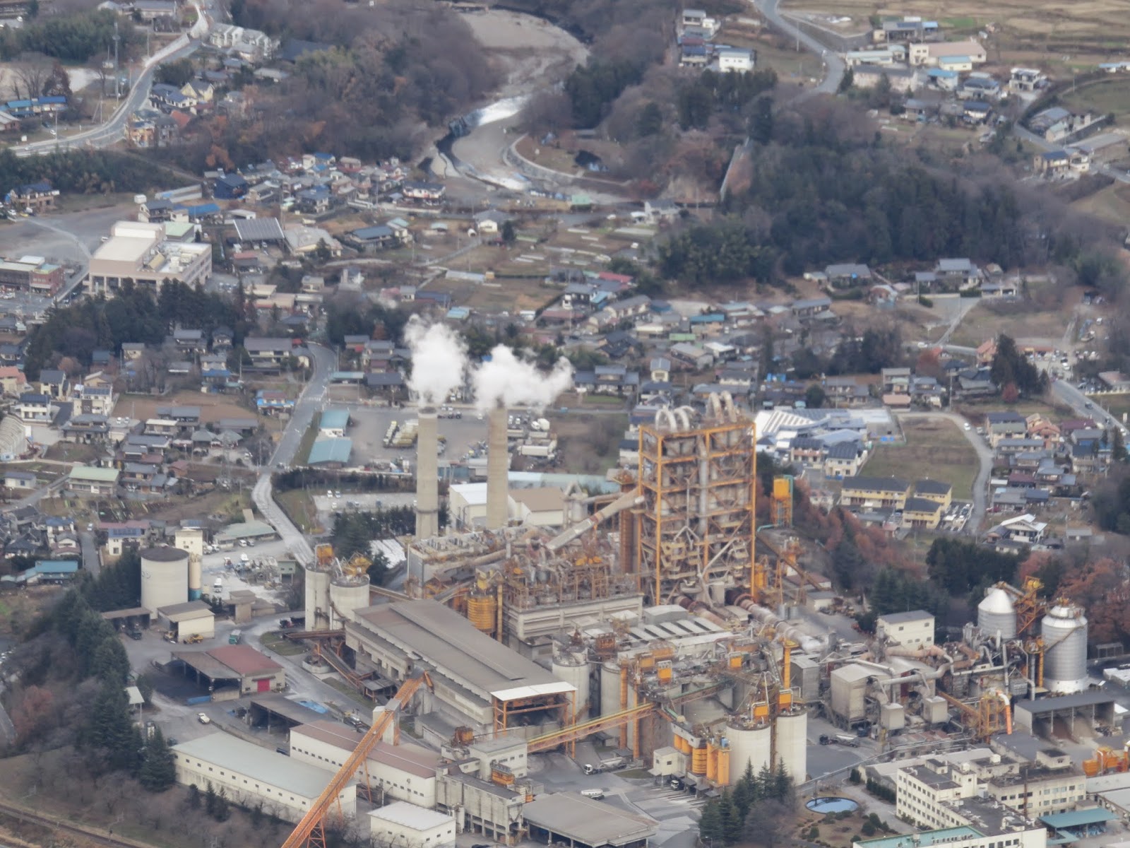

Limestone from the quarries is
transported to the many concrete plants that have sprung up below,
evidently centrepieces in the local economy, and there it is
processed to feed the Tokyo construction industry.
Perhaps
surprisingly, this has not reduced the mountain to some devastated,
mined-out wasteland. On the contrary, the southern flanks offer an
refreshing hiking experience where aside from the odd industrial
siren, the quarries rarely intrude on your day. Admittedly demand for
wood has done to the south what demand for concrete has done to the
north: much of Bukō-san's forest is young sugi
plantation rather than true wild woods. That said, these forests
tingle with the whispers of sacred sites and secrets from a
mysterious, more spiritual era gone by; at the large shrine on the
summit, for example, the evidence of devout observances goes back
centuries. And at the peak, if you plan well enough to make it there
on a clear day, there unfolds a glorious mountainscape that surely
ranks among the finest views in the region.


This walk is just over 9km long,
takes about 4-5 hours, and is a navigationally straightforward
up-and-then-down concern. There is no major technical challenge, but
it can get rather steep in places and presents a good workout for
anyone of reasonable fitness.
To
get there, take the Seibu
Ikebukuro Line to
Hannō
(飯能),
where you can change on the same platform to the Seibu-Chichibu Line
as far as Seibu-Chichibu
(西武秩父)
station. From here, take a taxi for about 20 mins. (approx. 2500 yen)
to Ichi-no-torii
(一の鳥居),
on the east side of the mountain. (You can also get off the train one
stop earlier at Yokoze (横瀬)
station and walk, but this takes an extra two hours along a road in
frequent use, not least by trucks trundling in and out of the
concrete plants on the way.) You'll finish on the west side at
Urayamaguchi
(浦山口)
station on the Chichibu Main Line; note that this line does not
accept PASMO or SUICA cards.
As an aside, like most walks in this
part of Saitama, you will pass Musashi-Yokote station on the way. By
means of a platform sign it proudly declares itself “the station
with goats", so be sure to look out of the window for reference.
 |
| “House of Goats”. |
 |
| Ichi-no-torii (一の鳥居). |

Starting at Ichi-no-torii, proceed
up the trail past the map board. The trailhead proper is about half
an hour's walk up this lane. Notice the marker stones that number the
route up the mountain: there is little danger of getting lost, but if
all else fails, keep an eye out for them. You start at No.1 and reach
the summit at No. 51.
 |
| Marker No.4. |
 |
| Marker No.7. |
 |
| These stairs mark the main trailhead. |
Soon after the stairs you come to
the little Fudō Waterfall (不動の滝).
A small enshrined statue stands next to it, one of many along this
route.
 |
| Marker No.10. |
 |
| Fudō Waterfall (不動の滝). |
 |
| The waterfall shrine, with Marker No. 18. |
 |
| The large marker bears the name of Bukō-san Mitake Shrine, which stands on the summit. |
Take
the right-hand path at the fork with the large marker stone. There is
now some significant but straightforward climbing to do through sugi
forest. In good time you reach a particularly outstanding sugi:
an ancient fellow whose residence here long pre-dates the industrial
hunger of our times. This is the Great Sugi
(大杉の広場),
which also marks an altitude of 1000m and a good spot for a break.


 |
| The Great Sugi. The happy sign indicates that the peak is one more hour's walk away. |

 |
| Marker No. 35, with some friendly resident personages. |
Another hour of climbing takes you
to the broad summit with its shrine and facilities.
 |
| Marker No. 40. |
 |
| The summit of Bukō-san. This is a bright and pleasant mountaintop with plenty of space. There is a toilet cabin, but it appears to be kept shut for part of the year. |
 |
| Bukō-san Mitake Shrine. |
Bukō-san Mitake Shrine (武甲山御嶽神社)
is intriguing. Information boards claim evidence has been found of
structures on this site dating back to the Heian Period (794-1185),
and of rituals and devout observances being performed here over the
hundreds of years since, especially during the Edo Period
(1603-1868). These would likely have occurred in the context of the
wider festivals and folk traditions for which Chichibu is well known,
such as the Chichibu Night Festival, many of which reflect extremely
old animistic practices.
Head behind the shrine to find a
short path up to the actual peak, where tremendous rewards await.
 |
| The main town of Chichibu occupies the left half of the picture. The concrete plants of Yokoze are visible in the lower right. |


 |
| A close-up of central Chichibu. |
 |
| In the distance are the northern towns of Saitama – essentially the far outer suburbs of Tokyo – and beyond them the mountains of Gunma. |

On my arrival this thermometer read
zero degrees Celsius, and a light snow was just beginning to fall,
the first of the season.
When you are ready to descend, go
back to the 51st marker stone where you emerged onto the summit, and
take the right-hand path down to a shoulder with a nice view of the
southern ridge. Turn right here and proceed down, taking care on some
steep sections. Some very good views of the other ridge will appear
to the left.


At
a small corrugated iron shelter, continue straight on down the ridge
with dark sugi
plantation on the left and brighter woods on the right. The path
leads on to a black bear warning sign, where it cuts left into the
sugi.
It then zigzags down for a while till it reaches the Hashidate River
(橋立川).

 |
| Hashidate River (橋立川). |
Continue
around to the right here, crossing the river to reach the start of an
old road. This is the trailhead from the Urayamaguchi (浦山口)
side.


One final stretch of walking
remains, west down this road along the river.


Near
the end you pass this large yellow torii,
to emerge at a bunch of teahouses beneath a 80m-high limestone cliff
which looms to the right. If you have time, it is worth turning right
past these to the base of the rock face, where stands an interesting
little temple.


The
temple is the Ishitaki-yama Hashidate Hall (石瀧山橋立堂),
and beneath it is a network of limestone caverns. For a small fee you
can enter and explore these caves, though be aware that it features
some cramped passages and ladders.

 |
| The cave entrance. |


Finally,
return to the road and continue down, bearing left under the flyover
then passing a cemetery. Urayamaguchi station (浦山口駅)
will come into view straight ahead – turn right to pass under the
railway then left up the hill to reach it.
 |
| Urayamaguchi station. |
You
will have to buy a ticket two stops to Ohanabatake (御花畑)
at the machine here; from that station it is a short walk to
Seibu-Chichibu Station and the train back to Tokyo. Occasionally
though Urayamaguchi has trains that connect straight through to the
latter. Either way, you can take satisfaction in some final views of
Bukō-san on the way back.

No comments:
Post a Comment