
Musashi:
the old province that encompassed the lands around what is now Tokyo.
Though abolished in 1868 with the introduction of the prefecture
system, the name was retained in many of its old districts, whether
for memory, or prestige, or differentiation. To this day, consider
all those train stations which bear Musashi in their names.
Oku-Musashi,
or “Inner Musashi”, now refers to the mountains of western
Saitama, the prefecture bordering Tokyo to the north, whose wilds
represented the inner reaches of the old Musashi province. These
peaks are relatively low, typically around 1000m or so, and stretch
across the west flank of Hannō
city as they rise, further west, into the great mountainscapes of
Chichibu (contiguous with Oku-Tama to the south, some
of whose mountains also
feature in this blog).
This was
my first hike in Saitama, and as with Oku-Tama and Tanzawa, these
mountains have their own distinct character. Another level closer to
Japan's central highlands, there is a certain Alpine something about
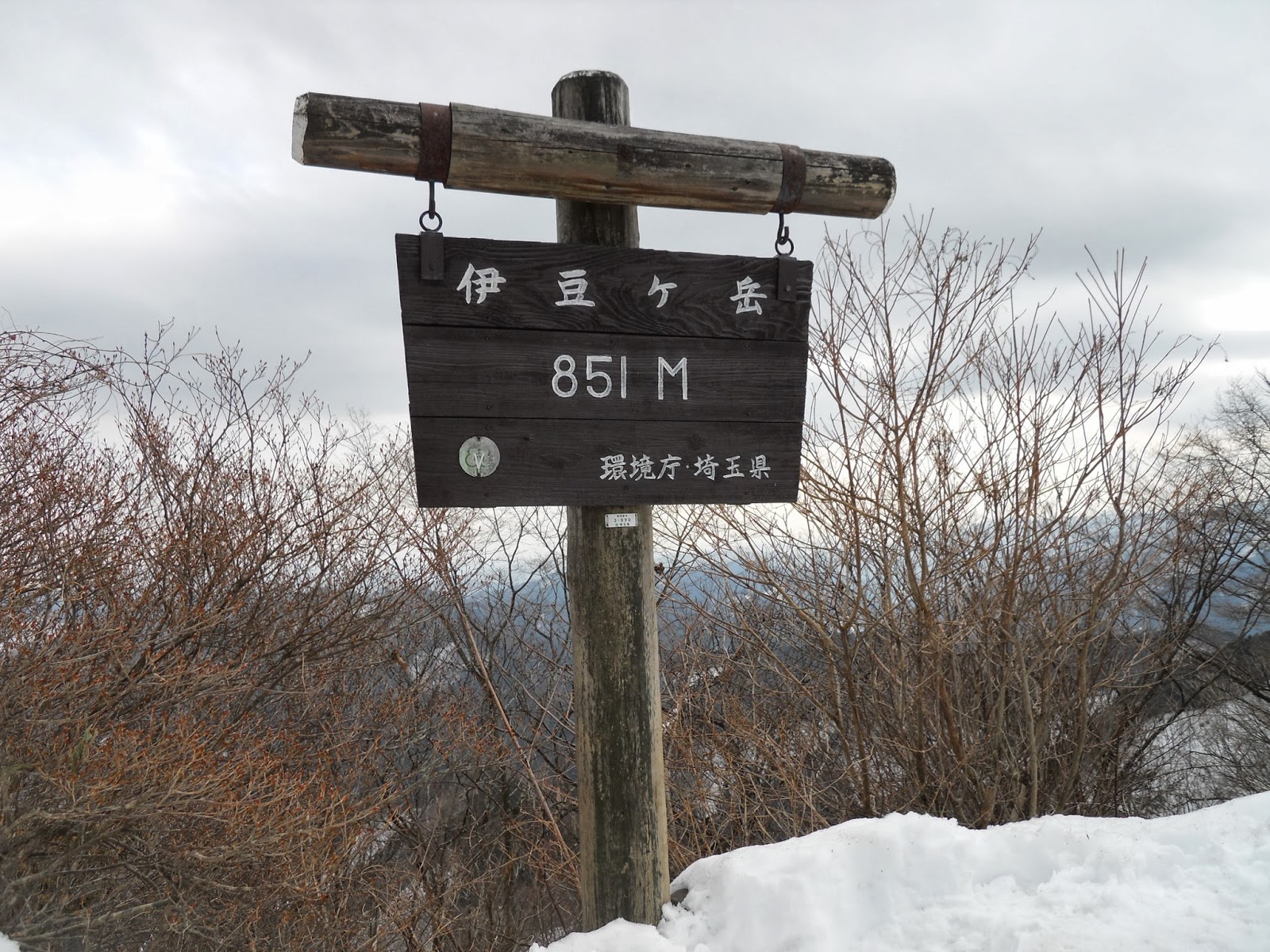
Oku-Musashi. My route began at Shōmaru
station on the Seibu-Chichibu Line – about an hour and a half from
Ikebukuro station in Tokyo – and ascended to the summit of
Izugatake (伊豆が岳),
the high point of the walk at 851m. From there a long ridge with many
sharp peaks trails south then east to Ne-no-Gongen temple (子の権現),
then descends, gradually, back into the valley past the mines of
Agano, finishing at Agano station. Though 851m might not sound like
much, in a February of brutal snowstorms it was in fact quite
satisfactory.

 |
| Quite satisfactory. |
The
result was an eight-hour slog through snow that reached a metre deep
in places, up and down sinew-shredding gradients fit for a lunatic,
along a course more properly popular for its thousands of colourful
flowers and rich greenery at saner times of the year. As such I will
not be presenting it here with the usual
detailed instructions, for the magnitude of the snow meant I had next
to no contact with the actual earth of the path at any point on the
route, so I cannot purport to advise on it. If your idea of a hike is
some pleasant exercise through bright and leafy nature, you might
want to give Izugatake a miss until summer. However, if it is in fact
a full-scale body-breaking, soul-wringing catharsis you actually
want, or if you are struggling with emotional poisons only the
cleansing force of the primal earth can purge, then by all means head
for Izugatake right now, for you will find nothing better than these
mighty snows to plough the toxins from your psyche.

 |
| “Beware of forest fires.” |
 |
| Ne-no-Gongen temple. |
If you attempt it, give yourself at least eight hours of daylight,
bring plenty of food and water, and go with maximum respect for the
challenge before you. Good shoes that can survive being under snow
all day (i.e. underwater) are essential; crampons are strongly
recommended. Izugatake is popular enough that you will run into other
people – likely elderly Japanese super-hikers – on the mountain
itself, but most of the ridge sees little traffic in these
conditions, and there are no services until near the end.
The route is long and often steep – imagine the North
Takao Ridge with fewer but higher peaks – but the biggest drain
on your energy will be the snow itself. Expect most of your footsteps
to immediately sink until your other foot is level with your thigh.
Expect also to fall forwards a lot when this happens; the deep, soft
snow makes this safe, but you still have to put the calories into
pushing yourself up again, and after dozens of times they start to
add up. Definitely not a place or season to faff around, then, but if
you know it is what you need, then you will come out a better person
than you went in.

From Shōmaru
station (正丸駅),
stairs go down on the right. The road leads right under the railway,
and heads up through Ōkurayama
village. It felt near-deserted; in deep hibernation, perhaps.

 |
| A lot of yuzu trees grow in this region. |

 |
| A bit of moving water, and more than a bit of not-exactly-moving water. |
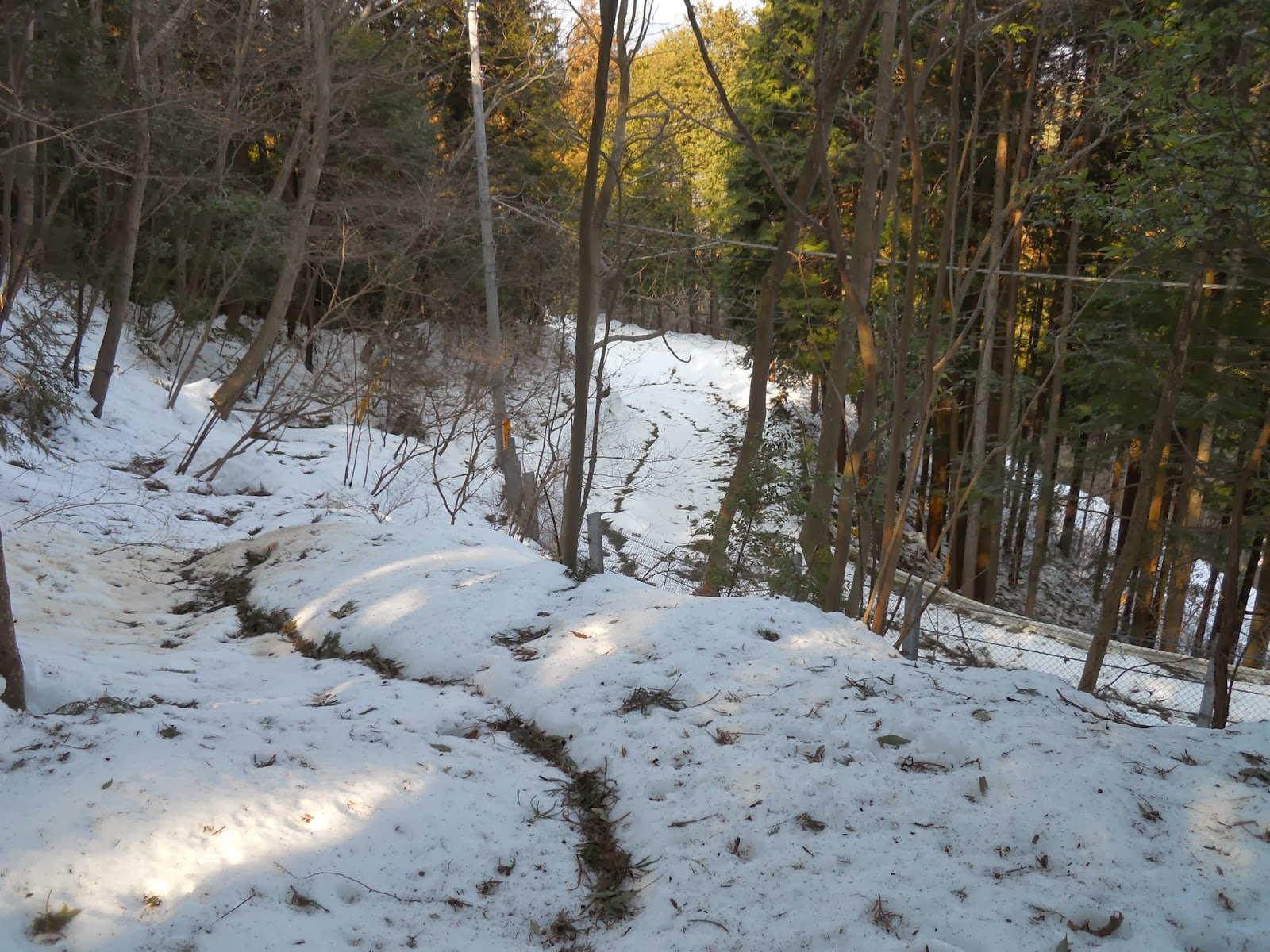
Soon the Izugatake trailhead
appears on the left, by a small shrine to the Horsehead Deity. From
here it is continuous snow for the next 15km.


 |
| Hornet warning. Typically these aggressive stinging insects are among a hiker's biggest nuisances – or hazards, if allergies are involved – in the Japanese wilds. Today I did not see a single one. We may wonder why. |
A sustained climb gets you up on
the ridge, where the first magnificent views of the day await. There
are views in all directions at different points on this route, across
the mountains surrounding this area on all sides. Here the views look
principally north along Oku-Musashi.


At the end of this ridge is a
minor peak, from where the summit of Izugatake rises in front of you.
And this last bit, between you and it, is this mountain's
famous highlight: the kusari-ba,
or “chain place”. By “chain”, it literally means a dangling
chain. By “place”, it means a 50 metre high, 40-degree rock face
which you climb via the assistance of said chain.

 |
| Looking up. |
This is not strictly recommended,
due to a risk of falling rocks, and there is an easier alternative
way. But it is provides one heck of a cathartic threshold, all the
more so in the snow. In a somewhat surreal experience, there was an
elderly Japanese gentleman climbing down the other way on this
occasion – unaided and with no specialist equipment, indeed – and
we met halfway, where we stopped for a rest and a chat.
This is what it looks like when
you get to the top and look back.

From here there is one more peak
to clamber over before the summit proper, but already the views are considerable.


 |
| The top of Izugatake, just ahead. |
There are a number of theories on
why it is called Izugatake: because, it is said, one can see the Izu
peninsula from it on a clear day; or because the name derives from
the Ainu language; or from “Yuzugatake”, on account of its many
yuzu trees; or from “Yutsugatake”, or “hot water harbour”, a
reference to the hot springs said to have gushed from the marshes
beneath it in times of old.
In peak hiking seasons I am
informed this summit gets crowded. In February, not so much.

The path down the other side,
south onto the ridge, is a steep and snowy affair.
 |
| The “path”. The snow dispenses with most of the trails, and for most of it you can basically walk anywhere. But there are plenty of footsteps to follow, and the route is well-signposted. |


The next peak is Komidake, with a gazebo. Probably a nice location
for a picnic when it doesn't look like this.


 |
| An experience you should expect to become quickly familiar with. |
There are multiple up-and-down peaks from here, on whose slopes the
snow presents its most dogged trials. In places it will slide you
back step after step as you try to climb it; elsewhere you will step
through to your waist and find yourself literally swimming through
it. Great fun, as long as you don't get careless.
 |
| More of the “path”. |
 |
| Much of the forest here is sugi plantation. Apparently the sugi and hinoki in this area produce exceptionally high-quality wood, some of which was harvested to build Edo Castle. |
This is supposedly one of the stretches with the best flowers. Though
none were out yet, there are these striking groves of Japanese
andromedas, whose evergreen foliage stands stark against the white.
In Japanese they are known as asebi:
a name it supposedly earned from its poison, with which it has a
habit, it is said, of intoxicating cattle and horses that eat it –
hence [馬酔木],
literally “drunk horse tree”.

Ahead is another peak, Takahata-yama (高畑山).
And then there follows more of the same: up, down, up, down, snow,
snow, snow. And then more snow.


Eventually the ridge drops, though only slightly, onto a road which
does not appear to see much use. This is Amamezasu Pass (天目指峠),
where a legend tells that a dragon god was enshrined. The story goes
that catching eels in the marshes was strictly forbidden, as the eels
were the dragon's relatives; so when a woodcutter violated this
prohibition by catching and eating one, the dragon god became furious
and washed away the woodcutter's hamlet.


Up the other side, you plunge straight back into snowbound eternity.
 |
| Yes, the idea is to climb that. |
 |
| I think that is a bench. |


Until at last, you reach a portion of ridge that opens out. This is
the approach to Ne-no-Gongen temple, from where views open out to the
southeast this time. Tokyo is just visible in the distance.

 |
| And that's the view northwest. Izugatake is the left of the two central humps in the distance. |
Just ahead you enter the grounds of Ne-no-Gongen from the back
corner. “Ne” refers to the Rat, the first sign of the zodiac, and
the temple is so named because it was apparently constructed in the
year, month, day, and two-hour timeframe aligned with that sign. It
is a sizeable compound considering its seclusion, and it enshrines a
god who protects people from leg and foot problems. Hence it is
popular with hikers, athletes and the elderly, and an enormous pair
of straw sandals stands there in dedication.


 |
| The main building. |
 |
| Notice the little one. |
 |
| Are you one of those foreigners who struggles with small shoe sizes in Japanese shops? If so, then this might be the place for you. |

 |
| This pair of guardians stands watch over the temple entry. |

Just out of the main gate is a little peak or plateau or viewpoint –
I have no clue which, as right now the heap of snow on it is larger
than whatever it actually is – from which you get still more views,
this time to the south, over the mountains of Oku-Tama.

From here it is another two hours down to Agano station. The path
joins a tarmac road for a bit: Ne-no-Gongen is supposed to be popular
in peak season and most of its visitors drive up. Today though I did
not encounter a single vehicle, and the only person around was a
caretaker clearing snow.

 |
| As you clear the snow, so does the snow clear you. |

Soon a path branches off again, providing a shortcut down the ridge.
I think this is usually a switchback, but in these conditions you may
as well cut down in a straight line.
 |
| Where the path leaves the road again. |

Gradually houses and signs of inhabitation start to appear. So
unfolds the final haul, down to the valley.


 |
| On the right past this bend is a large teahouse, which serves coffee and tasty-looking udon dishes. |


A heartwarming surprise awaited me on the final approach to the
village.

These kittens were sitting around on the road, and came up to me as
soon as they saw me. They sat around very close and played with each
other. The larger cats kept their distance and cast wary eyes at me
as I passed.


The lane ends at National Route 299 at the bottom of the valley.
Turning right just before it takes you to a final snowbound trail
leading up above the railway, offering some nice final views across
these mountain hamlets.

 |
| Just when you thought the snow was finally finished with you. |

 |
| The Seibu-Chichibu Line. |


At the end of this path is the Agano mine, where a final railway
crossing and foot tunnel take you to the train station – and where
all of a sudden, after trudging all day through the mountains, you
can board a warm and reliable train ride back to Tokyo.
 |
| Agano mine. |


 |
| Agano station. |
 |
| And in case you get any of the above wrong, you will find this conveniently prepared for you at the end. |
No comments:
Post a Comment