Some
mountains draw attention for the marvellous views they give across
their surroundings. Others, however, concentrate all that beautiful
intensity into themselves, and discharge it in through your boots
with every step you take. The mountain featured today falls into the
latter category, and is especially popular in the last days of
May, or early June, when the way to its summit
erupts in white azaleas.


Make
no mistake though. Hinokiboramaru (檜洞丸)
is no
overcrowded, tourist-encumbered Ōyama
or Takao-san. Proximity to these flowers is something each of the
people in these photos has earned by offering up buckets of sweat and
lactic acid. This 1600m peak, whose name denotes a “circle of
cypress caves”, lurks deep in the Tanzawa mountains, and an
excursion up and over it is less a hike than a swashbuckling,
sinew-grinding adventure.
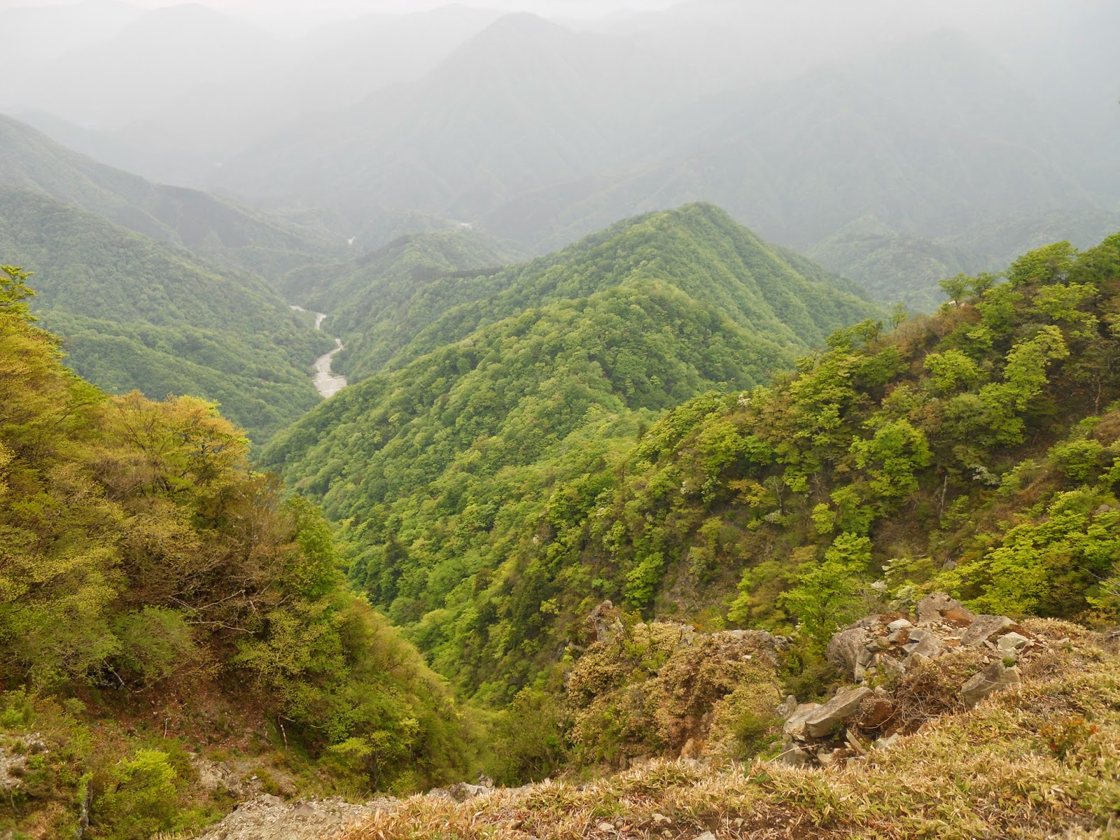
The beauty of the Tanzawa
mountains is in their diversity, and here that colourful variegation
is on show in all its glory. To demonstrate your worthiness to see
it, Hinokiboramaru lays down challenges no less mercurial: the paths
and environment transform before your eyes, zone after zone, each
time settling into a new configuration for you to negotiate. Expect
plenty of this:

And this:

And certainly no shortage of
this:

As well as a fair bit of this:

And if you are lucky, perhaps
even this:

So while it does not demand
specialist equipment or more preparation than other day hikes,
Hinokiboramaru is not for the faint of heart. The way up the mountain
is somewhat strenuous and often narrow of path, while the ridge that
follows presents challenges of an above-average technical difficulty,
featuring a rumbling series of ladders, hand-assisted or
chain-assisted rock climbs and boardwalks. Injury opportunities are
plentiful if you aren't careful, and if you get stuck, the only way
out of this remote mountainscape involves misery, expense and a
helicopter.
But
don't let that put you off. These mountains reward you commensurately
for every ounce of courage you put in, and so long as you approach
them with respect, a cool head, and even only moderate fitness, you
will be able to get from beginning to end of this route and feel
better for it. The area is well looked after by the Tanzawa national
park authorities, with excellent signposting and trail maintenance.
Even dogs and small children do this walk, as encountered on this
occasion, on a day when the average age of people on this hike seemed
nonetheless well over fifty.
Do,
however, plan well. Good
hiking shoes are absolutely essential, as is enough food and water to
last you the full way. Pay attention to the weather forecast and do
not go on a day with a significant chance of rain, which would make
this walk's many high and narrow trails too precarious. And avoid
trying it in winter unless you have special equipment for the ice and
snow, along with past experience with such conditions.
It
takes about an hour and a half to get from central Tokyo to
Shin-Matsuda
(新松田)
station
on the Odakyu Line, followed by another hour on the Fujikyū
Bus (1180 yen either way, regular and runs throughout the day, click
here for timetable)
to reach the West
Tanzawa Nature Classroom (Nishi
Tanzawa Shizen Kyōshitsu,
西丹沢自然教室),
where the walk begins and ends. As the walk can take a good six to
seven hours, an early start is strongly advised.
Phase 1: The Climb
The West Tanzawa visitor centre,
where you get off the bus, is a staffed and well-equipped staging
post for these mountain adventures. Inside there are good maps of the
area's trails, on which sightings of bears or other animals are
charted. There are also forms to leave notice of your route in case
of emergencies, and friendly mountain police who will advise you on
its latest conditions, including the state of the seasonal flowers.
There are also vending machines and toilets here.

 |
| Notice records of bear sightings and closed-off paths. |
 |
| “Black bears are THIS big.” |
After loosening up and exploring
some nice views of the river nearby, begin the walk by heading on
(north) up the road. This valley seems popular for getaways,
featuring several campsites and holiday cottage resorts. Pass one on
your right, and walk on for another five minutes to reach the
Hinokiboramaru trailhead. It will be clearly signposted on your
right, up through a tight rocky valley.

 |
| The trailhead. |

The ascent begins with about an
hour of narrow trails up this mountainside. The paths are in good
condition, but watch your balance.


In good time, you reach the
Gōrazawa convergence
(ゴーラ沢出会い),
a white and gravelly river bed clearing where the Gōrazawa
and Hondanazawa rivers merge. The first thing to do here is ford the
river. Once across, this is a good place for a breather before the
real climb begins.


 |
| The water is crystal clear in all the watercourses on this route. |
With the introductory section
over, you now face two hours of continuous uphill. That said, the
gradient is not too merciless. There is only one path, so you cannot
get lost, though keep an eye out for a very short signposted detour
to a viewpoint about halfway.
 |
| The way up. |
 |
| Red azaleas, a hint of things to come. For more of these striking red flowers, see this article on another couple of mountains in Yamanashi. |
 |
| Shortly into the ascent, this fellow made an appearance, slithering across the middle of the path with tongue flickering in and out. Then an elderly gentleman randomly came up behind us and chased it, whereupon it hurried away into the undergrowth. |


In the late spring and early
summer, this route is at peak popularity. While remote enough to not
overcrowd, expect delays at points where the narrow path or bouts of
hand-assisted climbing create bottlenecks. There are one or two
ladders to overcome as well.
 |
| An alternating one-way system. |

You will know you are making good
progress when the rhododendrons begin. And soon they are everywhere:
the trees erupt in singing clouds of white shiroyashio
(シロヤシオ),
interspersed with light purple mitsuba tsutsuji (ミツバツツジ).
This is the great seasonal highlight of Hinokiboramaru, so go now in
May or June to enjoy them while they are still out, and to avoid the
leech infestations of later summer.
 |
| Mitsuba tsutsuji (ミツバツツジ). |
 |
| Shiroyashio (シロヤシオ). |


The summit is not far now. The
trail levels off for most of the final approach, then suddenly
transforms into this Jurassic boardwalk affair.


At the end of this is the summit
of Hinokiboramaru. It is an interesting one as far as summits
go: a little plateau, broad and well-leafed, enclosed in trees but
with a few good views through the gaps.
There is plenty of space to sit
down for a well-earned lunch. Make the most of it, because already
the mountain contorts to challenge you in creative ways ahead.

 |
| This little fellow keeps a solitary watch over the summit. |

 |
| And here you can get a sense of what comes next. |
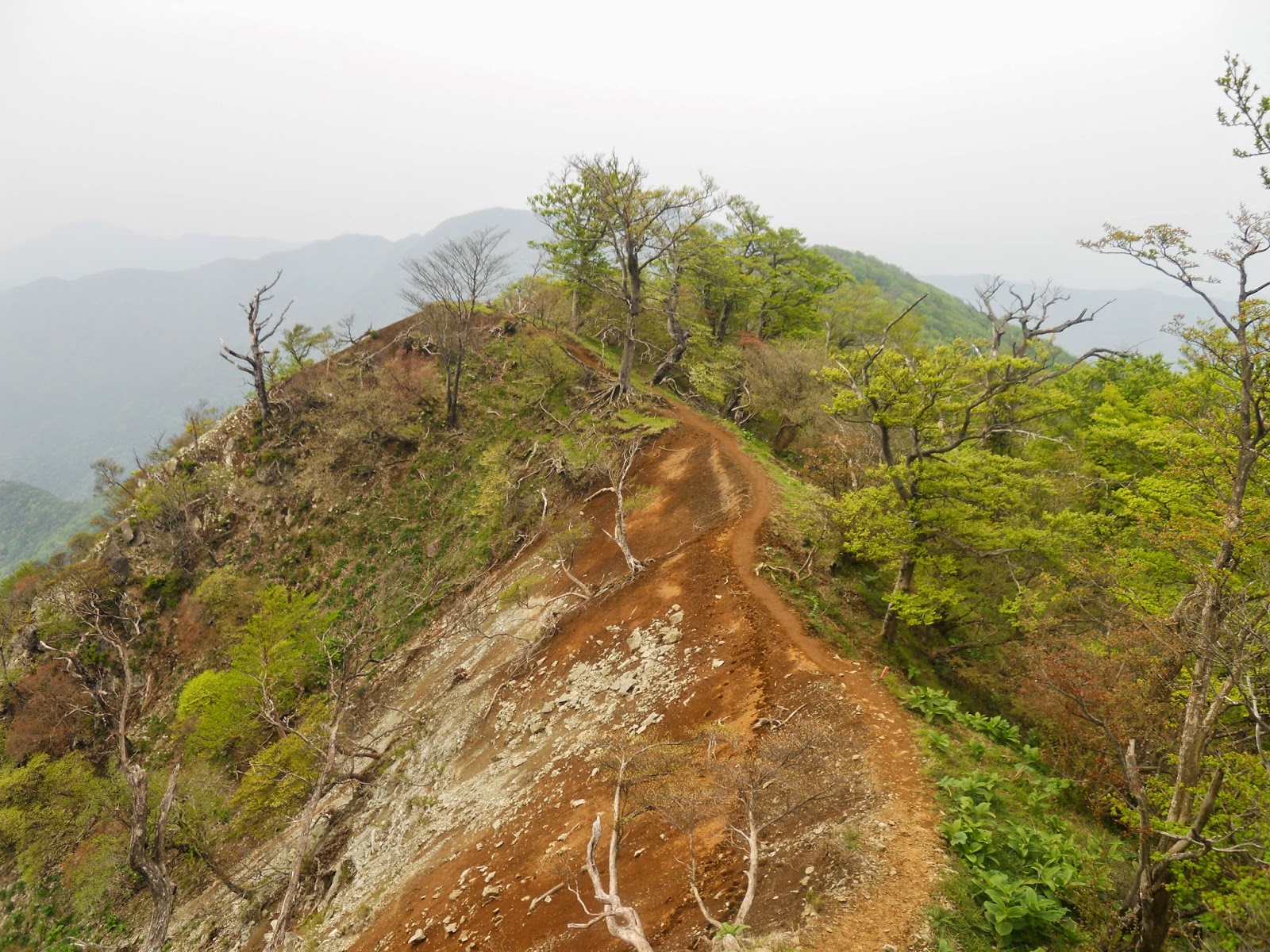
Phase 2: The Mad Ridge
Now comes the fun part. The ridge
from Hinokiboramaru to Inukoeji (犬越路)
is a precipitous rough-and-tumble concern, featuring a narrow rocky
trail suspended high above the ceiling of sanity, some half-dozen
ladders and chain-assisted descents down rock, and passage through
surreal landscapes that surely count among the Tanzawa mountains'
most outstanding.
Follow the signs from the summit
for Inukoeji to be presented with
this, noting the signboards which warn that this route is
significantly tougher than the ascent.


It is not as terrifying as it
sounds, nor necessarily more physically arduous than the way up. The
challenge is of a more technical nature, as there is a series of
narrow or rocky obstacles to negotiate. Take your time, and watch how
you step, exercising special caution in high winds and recognising
that you really do not want to get injured up here – but remember
to appreciate the exceptional views around you.


 |
| Several times you will need to get down small rock faces using a chain. |
After a long gauntlet of this
stuff, the path leads on into thickets of young bamboo, which grows
taller and denser the further you penetrate.


But
eventually, you will catch sight of this cabin ahead. This is
Inukoeji (犬越路),
the junction and shelter cabin which marks the end of the unrelenting
obstacle course.

 |
| Inukoeji (犬越路). |
Phase 3: The Way Down
At last the hard work is done,
and all that remains is a gentle descent from the wilderness. Follow
the signposts for Yōkizawa Deai
(用木沢出会),
for which the scenic path – known as the Tokai Nature Footpath
(Tōkai Shizen Hodō,
東海自然歩道)
– glides down to the Yōkizawa river valley.

Soon
enough the path will run parallel to the river, with multiple points
of easy access where you can wash your hands in it or admire the
water clarity. The path itself will doggedly insist on its narrowness
all the way to the end, traversing several small bridges and rocky
clearings before reaching a large iron bridge, and thereafter
rejoining the road you came in on at the Yōkizawa
Convergence (用木沢出会).

 |
| The Yōkizawa (用木沢). |


From here, you can finish with a
short stroll south (left) along the road, passing several holiday
cabin resorts, activity sites, and a compound with goats, until you
pass the trailhead up Hinokiboramaru on your left, and return, at
last, to the West Tanzawa visitor centre and bus stop.


If you made it, then
congratulations are very well deserved. Note that it will take you
another hour by bus to get back to Shin-Matsuda station – but of
course, you factored that in from the beginning.

No comments:
Post a Comment