
West out
of Tokyo, the first place you come to is Yamanashi Prefecture.
Yamanashi is landlocked, fertile and mountainous – Mount
Fuji occupies a big chunk of its southern border – and it is
here that the relentless urban expansion slows, trickling away into
valleys and mountain passes that rise, in the north and west, towards
the central Japanese Alps.
The Chūō
Line railway escapes straight out of the capital through here, and in
so doing traverses the municipalities of Uenohara and Ōtsuki.
These are “bedroom communities”, many of whose residents commute
into neighbouring Tokyo; but for the most part, these realms are of
mountains, forests, and picturesque little towns neither fully urban
– for all their farms and greenery – nor fully rural – for
their density and infrastructure. The mountains are relatively
gentle, in easy reach of the railway, and not as frequented as the
hotspots of Oku-Tama or the Tanzawa range. And this, along with the
views afforded by their special proximity to Mount Fuji, makes them
attractive and under-represented places to roam.


Here
is one of those mountains: Kuratake-yama (倉岳山),
or “warehouse peak”, in Ōtsuki.
This route is a pleasant up-then-down-again exercise, offering a bit
of everything: mossy ravines, kept cool and fresh by their running
rivers; high forests, a mix of evergreen and deciduous; and rolling
ridge paths, with impressive views off both sides through breaks in
the trees. On a clear day, expect to reach the peak to find the
massive profile of Mt. Fuji right there in your face.
The
walk is neither merciless nor long: Mt. Kuratake stands at 990m high,
but you get a relaxing 4km of horizontal distance for the climb, and
another for the descent, so at no point, save one or two very short
bursts, is the steepness particularly brutal. The whole thing can
easily be done within 5 hours, and will not trouble anyone in at
least reasonable shape.
 |
| Kuratake-yama (left), seen from the start of the walk at Torisawa station. |
What
makes it fun right now is that the paths have not been serviced since
the winter, in which time, it may be observed, tree falls and tons of
snow melting off the slopes have carpeted the routes in detritus.
This makes for many pleasant occasions of clambering over stuff, and
at times the path becomes indistinct, but in essence you simply
follow one river valley up to the ridge and the other back down
again, so there is no serious risk of getting lost, and the soft
ground generally cooperates with your soles.

To get there, take the Chūō
Line west out of Tokyo
– past Tachikawa, past Hachiōji,
and past Takao. Once out of Tokyo Metropolis and into Yamanashi, the
station you want is just a few stops ahead: Torisawa
(鳥沢).
The
walk starts there, and finishes at Yanakawa station (梁川),
the last stop before it. This area can be reached in about 1 hour 30
minutes from central Tokyo.

Exit
Torisawa station and turn right onto the main road. Follow this
(being careful of traffic) for about ten minutes, with the railway
parallel to you on the right. After crossing a stream, but before
reaching a signposted road fork, look out for a little wooden sign –
against the wall of a yellow house – pointing right for
Kuratake-yama and Takahata-yama (高畑山).
Turn right here, into a little
paved alley that ducks under the railway through a foot tunnel. Turn
left on the other side, and proceed with the railway on your left.


When you reach the above sign,
follow it right. You now need to navigate through some residential
back streets to reach the foot of the mountain to the south. Follow
the signs for it until you reach a larger road in front of a beige
building.

Turn right along this, and follow
it as it curves down to the left and across a bridge over the river,
which exhibits some beautifully clear water.


Keep going up the road on the
other side, past a map board, until you come to this X-shaped
junction, which has a tiny little sign to the mountain horribly
camouflaged against the wall. Take the upper-right lane here (left of
the mirror in this photo).

 |
| You will not see it until you are two metres from it. |

A few more minutes of navigating
back streets and signposts follows, till you pass a little shrine and
come to a closed gate.


Look closely to see the way
forward. That odd-shaped section slanted against the wall on the
right is itself a gate, and that is the bit you should open to get
past.
This takes you to a gentle ascent
through a meadow of sakura trees, drainage infrastructure, and –
after a short climb – a charming reservoir of crystal-clear water
set amidst the colours of spring.
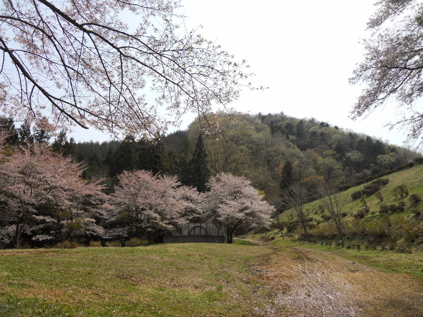
 |
| Watch out for bears. |


Now comes the ascent to the top
of the mountain. This entails about an hour and a half of steady
progression up a sheltered river valley, kept cool and moist by the
shadows and water. The sound of that water accompanies you all the
way up, by which it will appear that it ploughs its course with a
might far exceeding its scale. Moss-covered rocks are everywhere, but
the earth itself is soft and accommodating.
I do not know what this area is
like later in the year, but at the time of writing, you will find
more and more winter debris the further you advance. Branches and
dead vegetation litter the path, and on occasion fallen trees lie
across it. The biggest surprise of all will be patches of snow,
somehow persisting in the late April heat; in recent months this
mountain must have been covered in it, though now the remaining snow
is dense and compact, and for the most part easy to walk on.


Eventually this material will
start to devour the path. Keep an eye out for its telltale signs
though: the distinct white signposts, or the red marker posts and
ribbons round trees. Expect to cross the stream a few times, until at
last you rise beyond and leave it behind.


Soon the slope becomes steep, and
the top of the ridge will come into view. And this will be where the
trail finally fails you; I believe it properly becomes a switchback
path, but this time there was just too much detritus to make it out.
If you experience this too, the
solution is simple: climb straight up to the top of the ridge.

Once on the brow, turn left and
just follow it along. In short order an excellent path appears, too
high to be eaten up by the winter runoff.


You are now walking along the
municipal boundary between Otsuki and Uenohara. You will notice that
it also marks an ecological boundary between two distinct vegetation
zones, and good views should start appearing through both.


From here it is easy: just follow
the path along the ridge. You will pass a junction, where you should
continue along, ignoring the path that descends to the right. A few
more minutes take you to the final promenade, leading ahead to the
Kuratake-yama summit.


This is the high point of the
walk, with the best views, and an ideal spot for lunch. To the north
you can look back down at where you started; the river, the town and
the Chūō Expressway are all in
plain sight. The highlight however is to the south, where on any day
of reasonable air quality, the great mass of Mount Fuji will look
straight back at you.


 |
| This was not a day of reasonable air quality. In spite of the bright sun and cloudless sky, there was a disagreeable haze in the air which bothered the throat and choked off views for no reason. Mount Fuji was just visible to the eye, but sadly not to the camera. If you have a go at this one with photo-manipulation software, you might persuade it to show what it really saw. |
Head
down off the opposite side when ready. The immediate descent is
steep, and your footsteps will throw up a great deal of sand, so
tread carefully. But it soon relents into a more gentle incline to
reach Tachino Pass (立野峠).
A
good signpost stands at the pass. Follow the sign left for Yanakawa
station (梁川駅),
down into the woods.
The descending trail is very much
a mirror image of the one you took to get up there: another mossy
river valley lined with the remnants of winter. Again it is steady
going, and from here there should be no real danger of losing the
path.


About an hour from the summit,
you will come out onto a road. Turn left and follow it all the way
down, taking in the surrounding vistas in the afternoon sun.


As you cross the final bridge, look out and down from both sides for the last good views of the day. When you reach the main road, cross at the zebra crossing on your right; Yanakawa station is just up the slope on your left.


 |
| Even the view from the train station platform is nice. |
No comments:
Post a Comment